
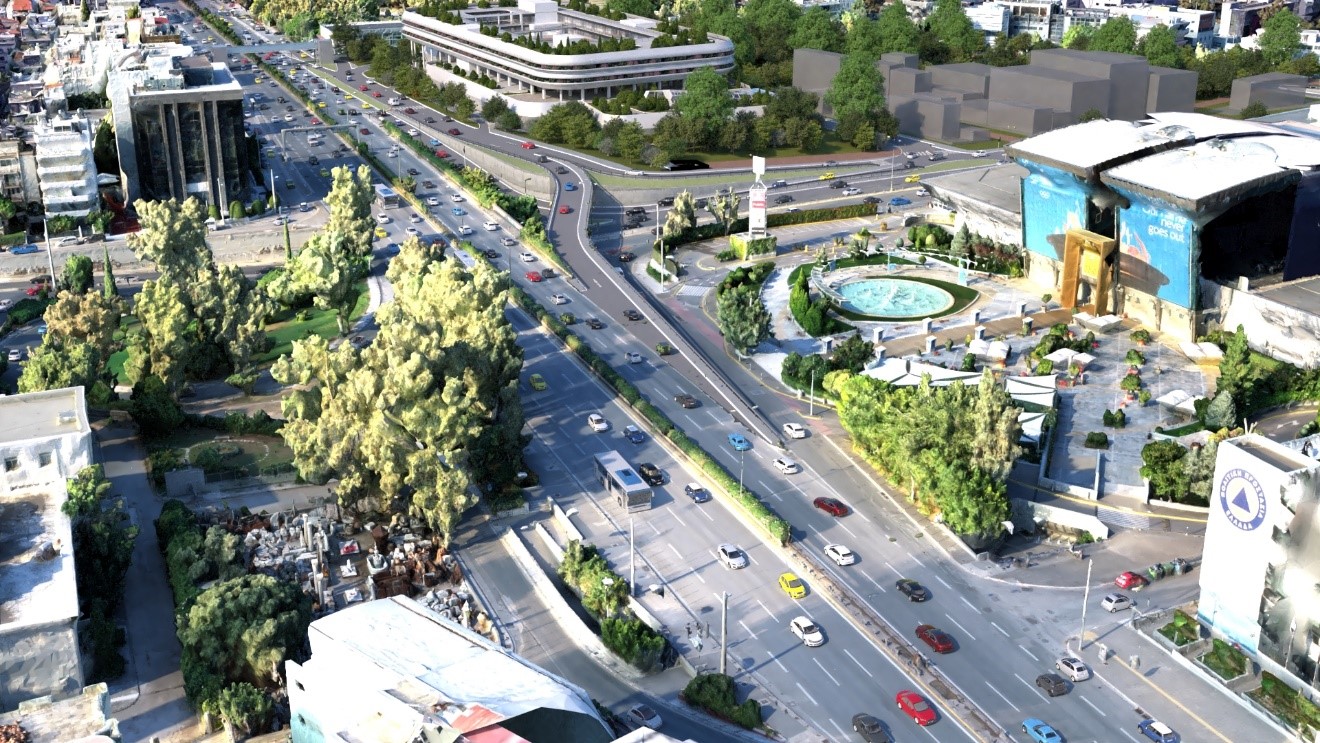
Project VORIA: Reality Modeling and 3D Simulations for a Landmark Urban Development in Marousi
ARGO-E harnessed advanced 3D modeling, traffic simulation and video animation technologies, transforming a complex road infrastructure design into a dynamic and easy-to-understand digital environment.
At the intersection of two of the most important road corridors in the northern suburbs of Athens, Project VORIA is taking shape: a multi-purpose tourism and entertainment complex expected to become a new destination for the wider metropolitan area.
The scale of the development and its location within a particularly demanding urban and traffic environment are accompanied by a complex set of interventions along Kifissias Avenue, Spyrou Loui Avenue and the local road network.
The geometric design of the road works and the traffic study were developed by DROMOS Consulting, which defined the proposed road layouts and the traffic interventions required to serve the new development.
Based on the technical and design data provided by DROMOS Consulting, ARGO-E undertook the transformation of the design into a comprehensive digital environment: 3D modeling of the proposed infrastructure, integration into the existing conditions, production of photorealistic visualizations, and development of dynamic traffic simulations and video animations. ARGO-E's scope also included recordings of actual traffic along selected routes and at different times.
From Plans to a Comprehensive 3D Environment
The project area is characterized by particularly complex traffic conditions. Kifissias Avenue, Spyrou Loui Avenue, the frontage roads, the existing junctions, and the connections to OAKA and the wider urban fabric form a demanding urban system.
Using the geometric design and traffic data as a starting point, the ARGO-E team developed 3D models of the proposed road layouts.
The new elements were integrated into the digital model of the existing terrain and surrounding urban environment, creating a unified 3D representation of both the current and proposed conditions.
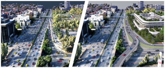
The 3D modeling enabled a precise understanding of the geometry of the works, the elevation differences, the relationship between the new infrastructure and the building, and its integration into the existing road network.
In this way, complex technical information traditionally presented through plan drawings, longitudinal profiles and engineering drawings was transformed into an immediately understandable digital environment.
A Living Model That Evolves with the Design
In projects of this scale, design is continuously evolving. New data, technical constraints and operational requirements often lead to significant revisions.
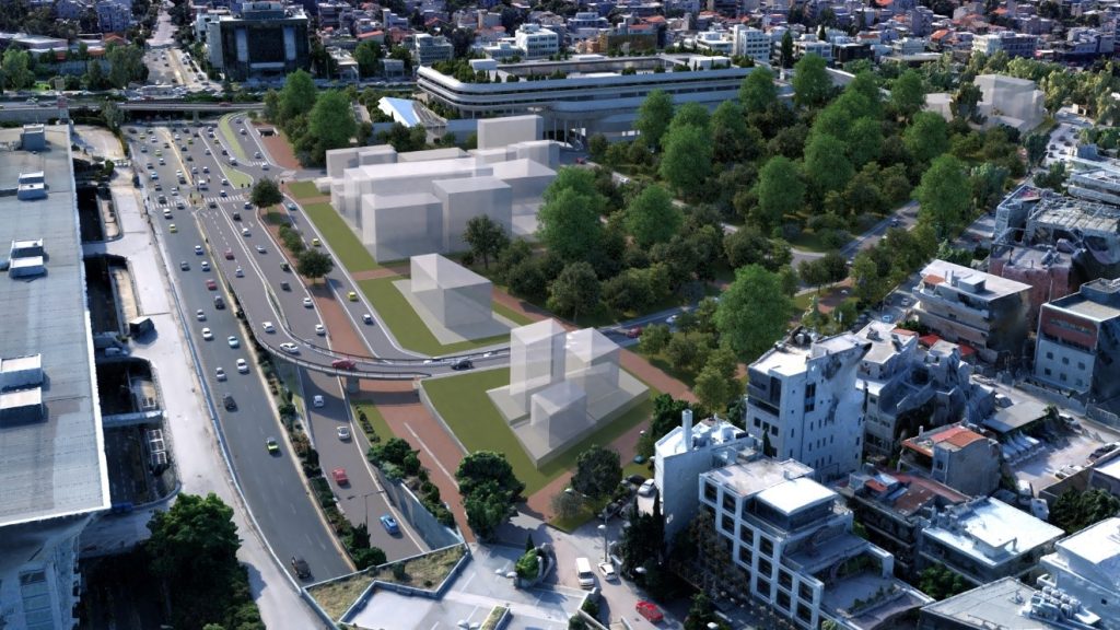
Throughout the collaboration, ARGO-E incorporated critical changes to the horizontal and vertical alignment of the road axes into the 3D model. The updates included, among other elements, the geometry of elevated and at-grade branches, bridge piers, U-turn locations, access points to the underground parking areas, pedestrian overpass ramps, and the connection of the development to the existing urban fabric.
This ability to update the model rapidly is one of the key advantages of Reality Modeling: rather than serving as a static image, the model functions as a flexible tool for design, review and communication, capable of following the different stages of a project's development.
Simulating Future Traffic Operations
The visualization of an infrastructure project does not end with the creation of its geometric model. To meaningfully assess a new road layout, it is also essential to demonstrate how it will operate.
ARGO-E created 3D traffic-simulation video animations, illustrating vehicle movements along the new road layouts, the operation of the entry and exit branches, and the overall integration of the interventions into the existing urban environment.
Virtual cameras were positioned at selected aerial viewpoints, allowing the project to be viewed from different perspectives. The animations were designed for use in technical presentations, management meetings and stakeholder information processes.
The simulation transformed a highly complex traffic design into a clear visual narrative. Viewers could follow the main routes, understand the entry and exit movements, and see how the new infrastructure relates to Kifissias Avenue and Spyrou Loui Avenue.
Connecting the Digital Model with Real-World Conditions
Alongside the 3D simulation, actual traffic was systematically recorded along representative routes on Kifissias Avenue and Spyrou Loui Avenue.
The recordings were carried out on different days and at different times, including peak periods, in order to capture the everyday traffic experience and create a representative visual record of the existing conditions. This material complemented the digital simulations, connecting the future design with the area's present-day reality.
Reality Modeling as a Decision-Making Tool
ARGO-E's contribution to Project VORIA demonstrates how Reality Modeling, simulations and animations can support the design of major developments and complex infrastructure projects.
Their value extends far beyond the production of impressive imagery. A properly structured 3D model can provide a shared communication platform for designers, investors, technical consultants, management teams and public authorities. It supports the early identification of critical issues, the assessment of alternative solutions, and the clear, immediately understandable presentation of the final design.
ARGO-E's Reality Modeling services are based on the production of high-fidelity 3D models and digital representations of real-world environments, while its simulation and animation services transform technical data into dynamic experiences that support collaboration and decision-making.
From Technical Information to a Visual Experience
In a landmark development such as Project VORIA, the success of the design depends not only on its technical completeness, but also on the ability of all stakeholders to develop a shared and clear understanding of the project.
By creating the 3D environment, incorporating successive design changes, recording actual traffic conditions and producing dynamic simulations, ARGO-E helped transform a complex set of technical data into a comprehensive digital experience.
Reality Modeling that captures the real world. Simulations that reveal how it works. Animations that make the project's future visible.
Are you planning a complex infrastructure project or a major urban development?
ARGO-E creates high-accuracy 3D models, photorealistic visualizations, technical simulations and animations that support the design, assessment and effective presentation of every project.
Contact our team and discover how we can transform your project's technical data into a comprehensive digital experience.